The parameters of Ground objects
Simutrans Version 0.99.xx
ground_32.zip (24.47 Kb) contains the source files of the objects on this page
Definition of basic ground
Copy to clipboard Obj=ground
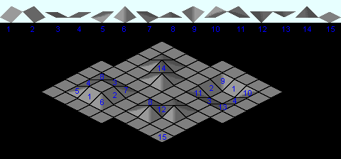
Name=LightTexture
Image[0][0]=texture-lightmap.0.14
Image[1][0]=texture-lightmap.0.6
Image[2][0]=texture-lightmap.0.7
Image[3][0]=texture-lightmap.0.2
Image[4][0]=texture-lightmap.0.4
Image[5][0]=texture-lightmap.0.11
Image[6][0]=texture-lightmap.0.3
Image[7][0]=texture-lightmap.0.12
Image[8][0]=texture-lightmap.0.5
Image[9][0]=texture-lightmap.0.1
Image[10][0]=texture-lightmap.0.13
Image[11][0]=texture-lightmap.0.10
Image[12][0]=texture-lightmap.0.0
Image[13][0]=texture-lightmap.0.8
Image[14][0]=texture-lightmap.0.9
|
The grey values correspond to the brightness distribution on the map.
The graphic arts are in the format 32x32 pixels. For other dimensions, the size must be adapted accordingly. |
Definition of coast
Copy to clipboard # these images define the beach transition
Obj=ground
Name=ShoreTrans
Image[0][0]=texture-shore.0.0
Image[1][0]=texture-shore.0.1
Image[2][0]=texture-shore.0.2
Image[3][0]=texture-shore.0.3
|
the colours correspond to water beach land
The graphic arts are in the format 32x32 pixels. For other dimensions, the size must be adapted accordingly. |
Definition of texture transitions
Copy to clipboard # these images define the slope transition
Obj=ground
Name=SlopeTrans
Image[0][0]=texture-slope.0.0
Image[1][0]=texture-slope.0.1
Image[2][0]=texture-slope.0.2
Image[3][0]=texture-slope.0.3
|
the colours show lower level upper level
The graphic arts are in the format 32x32 pixels. For other dimensions, the size must be adapted accordingly. |
Definition of textures
Copy to clipboard Obj=ground
Name=ClimateTexture
# water
# Wasser
Image[0][0]=texturen.0.0
# beach/desert
# Strand/Wüste
Image[1][0]=texturen.0.1
# tropic - Tropen
Image[2][0]=texturen.0.2
# mediterran
# Mittelmeerklima
Image[3][0]=texturen.0.3
# temperate grass
# gemäßigtes Klima
Image[4][0]=texturen.0.4
# tundra
# Tundra
Image[5][0]=texturen.0.5
# rocky/barren
# Alpines Klima/Bergklima
Image[6][0]=texturen.0.6
# snow
# Schnee
Image[7][0]=texturen.0.7
|
upper line: water, beach/desert, tropics, mediterranean, temperate, tundra, alpine, snow
lower line: graphics for the water depths and map edge
The graphic arts are in the format 32x32 pixels. For other dimensions, the size must be adapted accordingly.
|
Definition of water depths
Copy to clipboard Obj=ground
Name=Water
Image[0][0]=texturen.1.0
Image[1][0]=texturen.1.0
Image[2][0]=texturen.1.1
Image[3][0]=texturen.1.2
Image[4][0]=texturen.1.3
Image[5][0]=texturen.1.4
Definition of map edge
Copy to clipboard Obj=ground
Name=Outside
# hangtyp * animation
Image[0][0]=texturen.1.0
From this version onwards the copyright field will be shown while the pakset is being loaded.
In this field, the name of the pakset and its version number should be stored.
|
Definition of map grid
Copy to clipboard Obj=ground
Name=Borders
# backpart (obtained by (hang&1)|((hang&12)>>1)
Image[0][0]=borders.0.6
Image[1][0]=borders.0.2
Image[2][0]=borders.0.3
Image[3][0]=borders.0.4
Image[4][0]=borders.0.5
Image[5][0]=borders.0.1
Image[6][0]=borders.0.0
Image[7][0]=borders.0.7
|
The graphic arts are in the format 32x32 pixels. For other dimensions, the size must be adapted accordingly. |
Definition of cursor frame
Copy to clipboard Obj=ground
Name=Marker
# the front part (obtained by hang&7) for signle slopes
Image[0][0]=Marker.0.6
Image[1][0]=Marker.0.1
Image[2][0]=Marker.0.4
Image[3][0]=Marker.0.2
Image[4][0]=Marker.0.0
Image[5][0]=Marker.0.5
Image[6][0]=Marker.0.3
Image[7][0]=Marker.0.7
# backpart (obtained by (hang&1)|((hang&12)>>1)
Image[8][0]=Marker.1.6
Image[9][0]=Marker.1.2
Image[10][0]=Marker.1.3
Image[11][0]=Marker.1.4
Image[12][0]=Marker.1.5
Image[13][0]=Marker.1.1
Image[14][0]=Marker.1.0
Image[15][0]=Marker.1.7
|
The graphic arts are in the format 32x32 pixels. For other dimensions, the size must be adapted accordingly. |
Definition of slope fences
Copy to clipboard Obj=ground
Name=Fence
# Natural fence
# Zäune unbebaute Felder
Image[0][0]=fences.0.0
Image[1][0]=fences.0.1
Image[2][0]=fences.0.2
# building fence
# Zäune bebaute Feldern
Image[3][0]=fences.1.0
Image[4][0]=fences.1.1
Image[5][0]=fences.1.2
|
The graphic arts are in the format 32x32 pixels. For other dimensions, the size must be adapted accordingly. |
Definition of slope walls
|
Walls farmed fields
Copy to clipboard Obj=ground
Name=Basement
# West
Image[0][0]=-
Image[1][0]=ls-brickslope.0.0
Image[2][0]=-
Image[3][0]=ls-brickslope.0.1
Image[4][0]=ls-brickslope.0.2
Image[5][0]=ls-brickslope.0.3
Image[6][0]=-
Image[7][0]=ls-brickslope.0.4
Image[8][0]=ls-brickslope.0.7
Image[9][0]=-
Image[10][0]=-
# North
Image[11][0]=-
Image[12][0]=ls-brickslope.1.0
Image[13][0]=-
Image[14][0]=ls-brickslope.1.1
Image[15][0]=ls-brickslope.1.2
Image[16][0]=ls-brickslope.1.3
Image[17][0]=-
Image[18][0]=ls-brickslope.1.4
Image[19][0]=ls-brickslope.1.7
Image[20][0]=-
Image[21][0]=-
|
The graphic arts are in the format 32x32 pixels. For other dimensions, the size must be adapted accordingly.
|
if vacant fields build with mortar
Copy to clipboard Obj=ground
Name=Slopes
# West
Image[0][0]=-
Image[1][0]=ls-slope.0.0
Image[2][0]=-
Image[3][0]=ls-slope.0.1
Image[4][0]=ls-slope.0.2
Image[5][0]=ls-slope.0.3
Image[6][0]=-
Image[7][0]=ls-slope.0.4
Image[8][0]=ls-slope.0.7
Image[9][0]=-
Image[10][0]=-
# North
Image[11][0]=-
Image[12][0]=ls-slope.1.0
Image[13][0]=-
Image[14][0]=ls-slope.1.1
Image[15][0]=ls-slope.1.2
Image[16][0]=ls-slope.1.3
Image[17][0]=-
Image[18][0]=ls-slope.1.4
Image[19][0]=ls-slope.1.7
Image[20][0]=-
Image[21][0]=-
|


Die letzten Wiki-Kommentare